Thursday, January 30, 2014

Birds

Some recent pictures of birds from our recent weekend wanderings here in San Diego. We were not into birding before, but somehow, since we had experienced the joy of young peregrine falcons spring of last year, we were hooked. :)
Juvenile Peregrine Falcon

Before, whenever we see birds in San Diego, we would just dismiss them as "just birds"! Now, they are no longer "just birds", they are BIRDS! Special creatures with wings, serenading us with soothing songs and chants. 
Here are some shots of birds we captured lately here in San Diego.
TERN ( SORRY, FORGOT WHAT SPECIFIC TERN IS THIS )
PEREGRINE FALCON, LA JOLLA 

Wednesday, January 29, 2014

What Can Be More Fun?

What happens when cousins get together?


Well, just like when they were younger, they color the world FUN!!! Their kind of FUN!!!!


What Can Be More Fun Than Exploring Our Beautiful World on Foot?


And Enjoying The Heavenly Sights on Earth?


What Can Be More Fun Than Dancing With The Breeze?

Anacapa island


Inspiration Point, Anacapa Island, Channel Islands National Park
Best Time to Visit: Spring to Early Summer, by summer, the island becomes dry and less colorful, and the sea gulls have left the island, you are left with only the left-over smell of the gulls.
Closest Major City: Los Angeles, CA. The drive to Oxnard Harbor from Los Angeles is about an hour, and the ferry ride to Anacapa Island is about 45 minutes, plus or minus depending on the conditions.


Sea Arch, Anacapa Island, Channel Islands National Park

The pictures here I am attaching are not really the best of Anacapa, since when we visited the island, it was already late of June, and the wildflowers were mostly gone :( and most of the gulls that nested on the island probably had gone back to the mainland already. 


Gulls on a Bed of Wildlfowers, Anacapa Island, Channel Islands National Park

Tuesday, January 28, 2014

Our Philippines: Negros Occidental

Orchids from our Backyard in my Hometown, Bacolod City, Negros Occidental, Philippines

The Salitype Society, where I am also a member of the site, is hosting " Our Philippines " meme, where we feature our beautiful country, the Philippines.

I am from the province of Negros Occidental, which is located in the Western Visayas Region. I was born, and raised in Bacolod City, 
the capital city of the province of Negros Occidental. 
My Hometown Sunset
In this post, let my memories bring my story to how I have grown to love the great outdoors!

Friday, January 24, 2014

Training for a Grand Hike

South Kaibab Trail, Grand Canyon National Park

Let me start this post with one of my favorite quotes,  

" Everyone needs beauty as well as bread, places to play in and pray in, where Nature may heal and cheer and give strength to body and soul alike." -  John Muir (1838-1914)

This quote strikes me so much because it sums up why I love to be with nature. My desire to see the deeper beauty of nature keeps me moving and kicking my feet, bringing me priceless joys and inner peace that strengthens body, mind and soul. I have several hikes in my bucket list, two of them are in Grand Canyon National Park. Though we have hiked several trails of Grand Canyon, but we never really had completed a rim to rim hike. It is strenuous, about 20 miles round trip and 6000- 7000 ft descent/ascent. Add to this is another hike which is also in Grand Canyon, the Havasupai Falls hike. It is again about 22 miles round trip and 7000 ft descent/ascent. These days, I am both physically and mentally preparing myself for these hikes. 

One of the biggest challenges in Grand Canyon hike is that it is a reverse hike. At the top, it is cooler, yet as you go down, it becomes warmer. You start early of the day when it is cooler, but on your return,  you are facing the giant climb at higher temperatures and your feet may already be tired. My biggest weakness in hiking is facing high temperatures. Somehow, I get sudden headache when temperatures would soar past 70's! I know, 70F (21C) is very comfortable for some, but somehow, when I am hiking, I could not handle this kind of heat.  It is for that reason that most of our summer hiking trips always mean hiking in cooler places.
summer hiking at Lassen Volcanic National Park, California
( this may look cold, but it wasn't, up in California mountains, so much snow accumulation that last til summer, yet we were hiking in the 60s! 50s to 60s F or 10 to 20 C is my ideal hiking temperature. )

Tuesday, January 21, 2014

Queens Garden and Navajo Loop Trail, Bryce Canyon National Park, Utah

Thor's Hammer from Navajo Loop trail, Summer
Hiking Distance: 3 miles loop
Descending: 580 ft, then, Climbing: 580 ft
Best Time To visit:  year round for those who do not mind winter and summer temperatures. For a most pleasant hike, I believe early fall and spring is the best.

For photography, 
Late Fall and Winter: You will have the contrast  of orange rocks and snow.
Summer: Hoodos are fully exposed if you want full details of hoodoos ( very first photo above ). Late summer also has lots of thunderstorms, which most photographers love because of dramatic clouds over hoodoos. 
Early Fall: Hoodoos and Fall colors ( haven't been at this time, I believe it is very beautiful to have fall colors and hoodoos, sadly, my vacation time does not coincide. )
Spring: A combination of having the full details of hoodoos at exposed areas and some snow accumulation in some parts. Most photos below are from early spring 2009. 
Sunset Point, Navajo Loop Trail, Late Fall or Thanksgiving 

Utah rocks rock! They do! They will amaze you! For me, they even haunt me in my dreams, inviting me to go back there, again and again.

Queens Garden and Navajo Loop hike is the best way to see the hoodoos of Bryce Canyon. Most visitors usually are awed already looking down from the rim, and do not spend time going down the canyon. Even though the views from the rim are stunning, but the experience is entirely different going down Bryce Canyon floor. Nothing can compare being up close to the hoodoos, as close as you could hug them. Well, if only you could hug them since they are giants compared to our size. Hoodoos are pillars of rock erosion, and I have written about them before, in "Hoodoos Keep on Haunting Me".
Enjoying Bryce Canyon Even at -4F ( -20C), Late Fall

Thursday, January 16, 2014

Toadstool Trail, Paria Rimrock Hoodoos, UT


Betchai and The Toadstools

In  my post K Ka-Boom at Kelso Sand Dunes, I mentioned that nature has its special way of bringing the child in us. The experience is the same at Toadstool Trail. Seeing and being up close with the toadstool hoodoos tickled the child in us and we could not help it but just simply enjoy what the hoodoos have to offer. There is always something magical with the hoodoos, it was only this year's spring when the hoodoos haunted us back to Bryce Canyon National Park to enjoy the hoodoos wonderland. Never would have I thought that in the same year I would have fun with the hoodoos again, but in another nature wonderland.

Wednesday, January 15, 2014

Hiking Rainbow Falls at Mammoth Lakes, California

Rainbow Falls from the top view point

Location: Devil's Postpile National Monument, Mammoth Lakes, CA
Hiking Distance: 2.5 miles hike from Rangers Station to the top viewpoint, with additional 0.3 miles to the base of the waterfall. There are two choices on the way out, hiking back to Rangers Station for 2.5 miles, or hiking to Rainbow Falls trailhead at the Red Meadows Resort, for about 1.3 miles. 
Best Time: When Devil's Postpile National Monument Road is open ( which is summer). Usually, the road is closed after a major snowfall in November, and then, clearing of road from snow accumulation is done late spring or early summer, depending on snow accumulation. At other times of the year, the area can still be accessed for snowshoeing or skiing. 

Our hike:

We started our hike from Rangers Station, which is 2.5 miles away from Rainbow Falls. However, in 0.4 miles, we reached the base of Devil's Postpile.
Devil's Postpile

Fire and Ice created the unique basalt columns which is called Devil's Postpile. About 100,000 years ago, a lava flowed from an unknown location upstream. As the lava flowed down the valley, it ran into an obstruction which served as a dam to the lava's path. Pooling up to 400 feet behind the natural dam, the lava cooled. Conditions were such that the lava--that was incredibly uniform in its mineral composition--cooled at a very slow rate. As it cooled, it contracted and cracked, forming hexagonal columns. 80,000 years later, a glacier flowed through the same valley, revealing the sides and tops of the columns. Glacial polish can still be seen today at the top of the formation.- source: http://www.nps.gov/depo/planyourvisit/placestogo.htm
Glacially Polished Hexagons which could be seen at the top of the Postpile formation
Devil's Postpile Columns Up Close

Looking at the columns, it is so amazing how nature works, where the columns lack horizontal jointing, and very symmetrical. Rock formations like these are rare, but can be seen also in a few other places in the world.

From the base of Devil's Postpile, instead of taking the trail straight to Rainbow Falls, we hiked up first to the top of the formation to see the works of ice. After taking in the scenery, we went back down to the main trail towards Rainbow Falls. From the base of Devil's Postpile to the top viewpoint of the waterfall did not have a lot of elevation change, thus the hike felt easy, despite this is a high elevation hike ( some may be affected by thinner air at high elevation). 
Rainbow Falls from the Top Viewpoint

For a lot of people, the top viewpoint is the end of the hike. However, Rainbow Falls could also be enjoyed from the base. We hiked down extra 0.3 mile to the base via steep stairs. The steps of the stairs were uneven, so one should really be watching for their steps. 

When we reached the river at the bottom of the stairs, we could not help it but unzipped the lower portion of our hiking pants so that it become shorts. We wanted to test the water. We actually had swim suits in our backpacks. However, when we felt the water was cold, we decided it was not so worth it to swim since we still had to hike back. So, we just spent some fun time enjoying the waterfall from the base. What is fun for us? Photoshoot of course. :)

Here are some pictures from our photoshoot, with hubby as our official group photographer. :)
Us, Marching Toward the Waterfall ( this was the toughest part of the hike, we did not anticipate the current was strong, and the rocks were so slippery! )
We Made it to the Log :) yey yey for us!!
And Of Course, we Have our Individual Posing Contest :) Who Do you think won? Haha! 
Of Course, our photographer had to have his photo taken too :)

After we had enough fun, we hiked to Red Meadows bus stop, which is only 1.3 miles from the top viewpoint of the waterfall. The total hike is only about 4.1 miles. After hiking, we had lunch at The Yodler in Mammoth Mountain, which serves Bavarian Cuisine. 

Lodging: Mammoth Lakes and Mammoth Mountain is a skiing (winter) and mountain biking (summer) resort. Thus, there are many hotels, lodges, and vacation rentals in the area. 

Nearby Nature Parks:

Actually, there are so many beautiful sights in the Eastern Sierra of California, I only mentioned Mono Lake and Yosemite because that is what often others asked about.

** pictures above were from our hike last summer 2013.**

Desert Road Trip Thanksgiving Week 2009

The desert has its many interesting features, showing a deep beauty that has survived the harshest tests of time. However, aside from the inspiring beauty of the desert, it is the extreme peacefulness and serenity that invites us to explore it whenever we get the chance. Though we had thousands of pictures, but I decided to post 2 pictures a day from our trip.

Day 1 @ Death Valley National Park, CA
Badlands Creatively Carved by Nature, Zabriskie Point
Little Boy Enjoying His ATV, Dumont Dunes
( this is not part of Death Valley National Park, we just saw this recreational park on our way to Death Valley )

Day 2 @ Death Valley National Park, CA
Mesquite Sand Dunes, Early Morning
Dante's View
Day 3 @ Zion National Park and Coral Pink Sand Dunes State Park, Utah
Hiking @ Hidden Canyon, Zion National Park
Coral Pink Sand Dunes State Park, Utah
(the desert is more than just sands and cactus, this picture shows the immense pine forest next to the sand dunes)
Day 4 @ North Rim of Grand Canyon National Park and Page, Arizona
Tourists Sitting on the Cliff Enjoying the View of Grand Canyon 
Glen Canyon Dam, Page, Arizona

On Reaching El Cajon Summit

"You cannot stay on the summit forever; you have to come down again. So why bother in the first place ? Just this: What is above knows what is below, but what is below does not know what is above. One climbs, one sees. One descends, one sees no longer, but one has seen. There is an art of conducting oneself in the lower regions by the memory of what one saw higher up. When one can no longer see, one can at least still know." -- Rene Daumal

Hiking is one of the enriching and inspiring activities I and hubby do together. We do longer hikes on weekends, and short hikes on weekdays. We always plan our travels centered around exploring nature's wonders, where the greatest artwork and beauty could be found. Thankfully for us, our love for nature and photography inspires us to keep fit and take care of our health. I can't stress more than enough the benefits of hiking on one's health and fitness. So our backs, arms and legs won't hurt from all the weight we carry when we hike, we do a lot of stretches everyday! Aside from stretching, we do other exercises at home to improve our strength, flexibility and endurance. We aim to be hiking as long as we could, for there are just so many beautiful places to explore and be awed by nature.

Thankfully, San Diego is littered by so many mountains in its backyard to serve as our outdoor gym and local training for more strenuous outdoor adventures when we explore other places. Reaching the summit is always a celebration for us, of finding what is above. We do all sorts of more fun activities instead of turning around right away. After all, we deserved a much needed break at the summit since we hiked 5.5 miles with a climb of 4100 ft to the top. Round trip hike is 11 miles, which meant, we needed to hike another 5.5 miles on our return. Unlike most other hikes, where the return would be downhill, El Cajon Summit hike is an up and down hike. We still needed to conquer some steep uphill climbs in our return.

So, what are some more fun activities we do at the summit? Boulder scrambling! We love to conquer rocks, and rocks do bring out the child in us. But probably, more obvious in one of us, who do you think strike a better pose bringing out the better child within? Haha!

Is it me?...., I was making thumbs up sign for a great hike!

Monday, January 13, 2014

Coopers Hawk's Life in The Dangerous Lane

top right picture - coopers hawk examines his surrounding; middle right picture - coopers hawk dangerously dodged cluttered tree stumps in high speed to surprise prey; bottom right - birds fly for their lives......silence, where did the hawk go? ; bottom left - coopers hawk's reality of life: squeezes his/her victim trying to drown the head of his/her prey; top left - coopers hawk after food, searching again for an opportunity?


It is said that coopers hawk lives a life in the dangerous lane because when hunting, coopers hawk pursues prey with a great burst of speed through tree branches, which is a dangerous style of hunting. Coopers hawk does not have a notched bill like peregrine falcons to kill its prey. Cooper's Hawk squeezes its prey with its sharp talons and strong feet, and if there is shallow water, drowning its prey in the water.

Washington's National Parks Road Trip Part 3

Days 1-8 of Washington's National Park Road Trip Summer 2010
North Cascades National Park, Olympic National Park, Mt. Rainier National Park

This is the conclusion of a series of posts on our summer 2010 road trip to Washington's National Parks. You can find the summary of itinerary and from days 1-5 in Part 1, and days 6-8 in Part 2

Now, to continue to Days 9- 11.

Day 9: Mt. Rainier National Park
If you recall in my previous posts, our days 7-8 in Mt. Rainier National Park were on snow and cold rain weather. However, we were still able to do some hikes and some snow fun. We did not let the stormy conditions beat us. It was however our wish to see the face of beautiful Mt. Rainier reflected, which we were only able to photograph from air during our flight to Washington.

Did the weather improved on our 3rd day at Mt. Rainier? After breakfast, when we went out, there was no rain nor snow, but the sky was not very promising. Anyway, we decided to do some more sightseeing. We drove North from Paradise. Here were some pictures from our sightseeing on that morning.
Roadside waterfalls, wildflowers and Fogs @ Mt. Rainier National Park

The visibility was actually very poor, maybe, just a few feet. We therefore did more up close pictures of wildflowers instead. If we were not paying attention to the sounds of nature while driving, we would not actually see the roadside waterfall above because of very poor visibility. However, when we heard the sound of raging water, we safely stopped at the road side parking lot ( which are view points, but no view, haha!), and walked a little bit to find the source of the sound. I believe among us, it was hubby who has the best eyesight, for he was able to find the waterfall. :) 

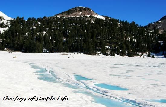
After the waterfall, we stopped by at one of the most photographed lake in Mt. Rainier, however, we did not see anything but ice and fog.
The top right picture above would have been the view if the lake was not frozen and the visibility was better. The top left and bottom picture above was the condition of the lake when we got there. 

Afterwards, more fog rolled in that we could hardly see anything. Fog is lovely if it is not as dense and when you are not on a windy mountainous road. But when it covers everything you see, it is different. We had driven quite a distance away from Paradise ( the center at Mt. Rainier) and we knew we drove a very mountainous road with drop-offs. Not seeing the road side, where our car could slip and fall down the cliff anytime was scary. We were thinking of waiting for fog to clear before driving again. However, there were news a night before about hikers lost in the blizzard, but rescue operations could not start yet due to terrible weather conditions. We did not want also to end up stranded on road. That was the point where we turned around and went back to Mt. Rainier's hotel and visitor services. We just drove very very slowly and very carefully.

When we got there, some snow started falling again, but unlike the previous days, there was very strong wind blowing also snow from the ground into the air making the visibility and conditions really worse. We laughed and told each other, "whew, what A SUMMER VACATION!" Usually, in National Parks, the food court, museums, theater, etc are not crowded at all because everyone would be outdoors exploring. But on that day, everywhere in the area was so crowded because where else would the stranded visitors go? Most hikers usually are not wimps, they would still hike in rain and snow, remember, we did for 2 days. But not when the conditions are very treacherous like that day, from misty to almost zero visibility. We kept ourselves busy watching the short movie on Mt. Rainier's Natural History, looking at museum displays,
the left photos above are from the museum- the right photos were taken by me(top and bottom ) and hubby(middle )

listened to talks, shopped for Mt. Rainier souvenirs such as hats and hoodies, and well, ate and ate....and had WARM SOUP after WARM SOUP. Despite however looking only at the pictures of Mt. Rainier in the museum, still, we love the place! We knew however, we needed to go back to Mt. Rainier some other time to see its peak beauty, like paradise in bloom!

The weather did not improve at all. It was our most relaxing day, physically that is. However, when you don't do anything actually, you feel more tired. There was just no rejuvenating energy pouring in from staying indoors, watching the bad weather outside. 

Day 10: Left Mt. Rainier National Park For Columbia River Gorge National Scenic Area, Washington/Oregon.
Pictures from Day 10- A Better Weather Day

Before we left Mt. Rainier after breakfast, we checked the weather forecast first if there is a possibility of clearing. However, the forecast was not very inviting for us to linger longer at Mt. Rainier, that we decided to start heading South to Columbia River Gorge, where the weather may be better. We left Mt. Rainier without seeing the mountain. Although we were there, but we only saw parts of it. Despite the unpleasant weather at Mt. Rainier, we still had a wonderful stay there. Whatever we had explored convinced us it's worth coming back, someday!

Our first stop on our drive South was Mt. St. Helens National Volcanic Monument.
Mt. St. Helens National Volcanic Monument, From above and from Below Ground

Mt. St. Helens is not in the direct route to Columbia River Gorge, in Oregon. However, because it was kind of in the middle, we decided to take the route ( though a little bit longer ) that would make us pass by Mt. St. Helens National Volcanic Monument. We were blessed with a very good weather South of Mt. Rainier, that we were able to enjoy the scenery around Mt. St. Helens. Mt. St. Helens erupted May 18, 1980, being shaken by an earthquake. Its north face collapsed in massive rock debris avalanche. The eruption lasted 9 hours, dramatically changing Mt. St. Helens landscape. Mt. St. Helens is another hiking wonderland in Washington, however, we did not have enough time to really explore the area. We decided instead to explore Ape Cave, a 2000 year old lava tube that was formed by basalt flow from a vent on the southern flank of Mt. St. Helens. We're so used to hiking up the mountains in our hikes, that we decided instead to go down and see what is under Mt. St. Helens.
In order for us to explore Ape Cave, we had to go down several flight of stairs, in the dark. But because of time constraints, we only explored the lower tube. It is not possible to go directly to upper tube from lower tube. Instead, we had to go back to the opening of the lower tube, hike 1.5 miles inside the forest before entering the mouth of the 2nd tube again.
After Mt. St. Helens, our next stop was Columbia River Gorge, which was actually our destination.
Columbia River Gorge National Scenic Area, Washington- Oregon

After taking in the beauty of Columbia River Gorge from the roadside viewpoints, we drove to Mt. Hood, hoping we could go skiing in the summer. Some of the ski slopes in Mt. Hood are still groomed for skiing even in the summer. We thought it would be our highlight of the day. But, when we got to Mt. Hood, we learned there were no rentals in the summer. Those who ski bring their own gears. Well, we did not pack even a trekking pole, so we would not have to check in our luggage during flight. We decided instead to just have another photoshoot and snow fun at Mt. Hood. 
From Mt. Hood, Oregon 
( the bottom right picture is Mt. Adams as seen from Mt. Hood )

After several days of stormy weather in Mt. Rainier, we had a blast of good weather in Mt. St. Helens, Columbia River Gorge and Mt. Hood. 

Day 11: Half Day White Water Rafting at White Salmon River and Drive to Portland, Oregon for fly out the next day
US (the one wearing red was our raft guide ), Ready to Take the Rapids

We had a blast in our half-day class III-IV white water rafting. It was both fun and thrilling to feel and ride the raging water. We had to pass one waterfall, however, we were asked before we started if we were up to it. If we are not up to it, we could skip the waterfall. We were warned that is the point where most fall off the raft. We were briefed however what should we do instead we fall off the raft in the waterfall and in the other more challenging rapids. We felt very confident after the briefing that we all agreed to pass through all obstacles, since that is the fun part of white water rafting. Did anyone fall off our raft? Happy to say, none. :) But there were several in the other rafts who fell off. 

The water was frigid cold, but we wore wet suits, and waterproof outer layers. Funny, during the orientation, we were told, "if you have anything cotton, like shirt or underwear, better change now, as cotton is the most unpleasant in this condition." Well, no one rushed to change, which meant everyone was used to outdoors that learned to unfriend any cotton clothing. Everybody came prepared, to enjoy and ride the rapids. 
 Us, White Water Rafting at White Salmon River, WA

White water rafting concluded our 11 days exploring of 3 Washington National Parks and Columbia River Gorge. We placed it at the very last day so that whatever happens, we already had explored all places we wished for this trip. :)

We definitely will be back in this part of the West Coast for more wonderful exploring. 

Fun Friday: Q is for Quest

A Hiker in Quest for Adventure
It was Fun Friday yesterday once again in our group Blogging For Fun. We are doing an A-Z meme, and this week, we are working on the letter Q! As you can tell I am late ( it is a Saturday now), all because we were on a Quest for Adventure yesterday. :) Friday was the start of my 4 day President's Day weekend, and we love always to spend our time out of the doors, spending some time with nature. Exploring our outside world is our form of bonding. Together, we share the fun of exploring our natural world every weekend or whenever we are on vacation :) Let me share with you our Quest for Adventure yesterday :)
Since San Diego County is riddled with numerous ecotones- which are areas between two adjacent but different geographic regions or ecological habitats, such as forest and desert, our quest for adventure yesterday involved exploring two different words in but one place.
We started our day driving to Mt. Laguna, which is in Eastern part of San Diego County. This was the scenery from the trail head.
 Snow Covered Slopes, Mt. Laguna, San Diego County
Our hike started meandering through pine forest, then, slowly, the pine and oak forest changed to low lying chaparrals, and finally to a more exposed slopes of manzanita and mahogany brush. After that, we did not proceed any further, since it would be a very tough and challenging vertical drop to the desert floor.
end of our hike @ Monument Peak with the Anza Borrego Desert State Park in front of us
At the top, we just enjoyed the expanse view of earth and sky. 
Hiker Taking in the Desert Scenery to His Front
The desert view above is totally different from this mountain view below, both taken at my vantage point yesterday.
Looking Back to Our Trail Head at Mt Laguna
This drastic change in environment creates a very sharp boundary between the geography of forest and desert. This type of scenery however, is not unique to San Diego only. There are a lot of this type of ecotones in the Eastern part of California. 
Anza Borrego Desert State Park
 After this mountain hike, we moved down and took another trail at one of the wild hidden canyons of San Diego County, the San Diego River Canyon.
San Diego River Canyon
The hike started with the view of a waterfall to the North.
Mildred Falls
There were a lot of trails to choose from at the trail head, and we chose the one that will lead us to Cedar Creek Falls. I was excited to see hints of a good wildflower season in this trail, there were already some early bloomers, such us poppies, phacelias and indian paint brush. 
Early Bloomers in the Trail
Strange it may be for some to see snow, waterfalls, wildflowers and the ocean in a short distance, but these are some of the special sights  we treat ourselves for living in California. After a long descent along this trail, we took the left trail that descended abruptly and in some parts through slippery rocks towards the top of the waterfall.  
Cedar Creek Falls from the top
I was too scared to scramble further down the rocks to get a good view of this 90 ft tall, 50 ft wide waterfall from the bottom. Some people brave enough and probably with more experience rock scrambling and bouldering would go down from the top through these slippery rocks and boulders. However, that type of adventure was not for us, since we don't feel like we are really skilled to doing that. We could opt to continue from where it branched earlier, that is go down all the way to the bottom of mountain and turn left to follow the creek, but it was already 3:30 pm, less than 2 hours before sunset. Considering we would have a long way to climb back up, we decided to just go back up to the trail head before the sun sets. As we were heading up back to the trailhead, I entertained myself with the amazing contrast of the blue sky and rock strewn mountain in front of me.
Before reaching the trail head, I saw some reflection on this small puddle of water.  
Mildred Falls (looking very small from afar) and Reflection
It was a great decision to go back instead of continuing down, since when we got back to the car, I could feel my legs were aching and really tired, must be from the snowy slopes in the first hike, and the slippery rocks trying to find our way down of Cedar Creek Falls but did not succeed. Had we gone down, I do not think I would have the energy to go back up.
On our drive home ( going West ), nature continued to treat us with the sun setting in front of us and the colors of the sky were changing. The pictures below were taken from a moving car, thus may not be that very high quality, but just would like to share how nature continued to treat us with wonderful sights after leaving the desert and mountains to go back to the coast.
Sunset
Peaceful Countryside of San Diego County
Today, as you can tell, I am just resting my legs :) but the day is still long, and we may end up still doing something outdoors before the sun sets.