Tuesday, December 30, 2014

The Challenge of Choosing That One Picture

La Jolla Coast Boulevard Tidepools @ Dusk and Sunset

Whenever I am faced with the challenge of choosing that one picture and I have a hard time choosing which one, my answer always is to make a collage, then, I do have one picture, a picture collage! :)

In the above collage, I asked the help of hubby which one to choose. From the collage above, at first, his choice was the top left picture. But then, after I showed him two at a time, and asked him which one he likes better between the two, the choice for that one picture changed. Could you tell which one of the 6 pictures below finally ended to be that one picture? 

TOP LEFT PICTURE

Monday, December 29, 2014

Hanging on to Fall

Fall in winter, these are the sights adding simple joys in my early morning walk. I love that we don't have white Christmas, but a golden one of warmth and love.


Saturday, December 06, 2014

A happy Cat-urdate

It has been a while since last post here. Truth is, I've never gotten a chance to work in my own personal laptop since summer break ended late August. I get to share pictures in my Facebook because it's easy through cell phone. Somehow, I forgot about blogger mobile. But now, am back, with mobile posting. :) here are some happy weekend wandering and caturdays I took today.


I may not have the luxury of time to blog these days, but weekend wanderings and enjoying outdoors aren't sacrificed at all, as they are part of my rejuvenating activities.

Leaving you with these happy mom and baby cheetah pics.

Wednesday, October 22, 2014

Fun Friday: S is for San Diego

Our Blogging for Fun group is doing an A-Z  meme for our Fun Friday (or is it now Saturday Special for me since I am always a day or two late) , and this week, we are working on letter S.
S is for San Diego
and all the other S in and around San Diego, such as:
The Sea and the Snowcapped Mountain
Sunset By the Sea
Splashing Waterfall
Sea Caves
Sea Lions
Seals
Surf
Sea Gulls
Sea Star
Sea stars
Succulents by the Sea
And there are probably more S in and around San Diego that I can add here, however, my other S pictures such as the squirrels and snails were somehow hidden in my portable hard disk drive and unlabeled that I still have to look for them :( 

Hope everyone is having a good weekend. 

Tuesday, October 21, 2014

North Cascades National Park

Ross Lake, North Cascades National Park, WA
From Seattle, we drove 120+ miles North East to North Cascades National Park. North Cascades National Park sits on the border of US and Canada. This park is also known as the Alps of the West,  features rugged mountain peaks,
Rugged Mountain Peaks Seen From Easy Pass Trail
cascading waterfalls everywhere,
One of the Many Nameless Waterfalls We Found On The Trail
thick forests,
Forested Trail to Easy Pass, North Cascades National Park, WA
deep valleys, long valley lakes,
Diablo Lake, North Cascades National Park, WA
Lakeshore, North Cascades National Park, WA

glacier fed pristine rivers, 
Emerald Waters of the Skagit River, North Cascades National Park, WA
and more than 300 glaciers adorning its rugged peaks, the most glaciers of any US park outside of Alaska. 
Glaciers and Snow, Mount Shuksan, North Cascades National Park
Some have glaciers thousands of years old and at 1988/1999 receive world record snowfall at 1140 inches of snow. 
Summer ( June 30, 2010 ) at higher elevations of North Cascades National Park
In my next posts, I will be featuring some of our hikes at North Cascades and a more detailed exploration of the park. 

Sunday, October 12, 2014

Hiking Mt Woodson

Mt Woodson is another local hike in San Diego that is easily accessible, yet hiking its trail feels like an escape from civilization.

It is littered by giant boulder outcrops, and from the summit, one can enjoy the ocean-to-mountain views. Near the summit is the now famous Potato Chip Rock, which is the result of exfoliation and weathering. There are many ways to reach Potato Chip rock or the summit of Mt Woodson. The three different trailheads for this hike is what I will be sharing in this post. source: Afoot and Afield: San Diego County: A Comprehensive Hiking Guide
Best Time to Hike:  During the cooler months, November to May. If hiking in the summer, start early of the day, or choose the cooler days of summer, because most part of the hike is on exposed trail.

Option 1: Mt. Woodson from Lake Poway

Lake Poway from Mt. Woodson Trail

Mileage: approximately 7.2 miles roundtrip
Change in Elevation: 2300 ft gain and loss
Parking: Lake Poway Recreation Area Parking, there is parking fee of $5.00 for non-Poway residents during the peak months April- October.

Monday, October 06, 2014

Cleetwood Cove Trail, Crater Lake National Park

While we were on our way to Crater Lake National Park, we had been planning to do some activities other than hiking. It is not that we got bored of hiking, but then, we were thinking of doing some water activities instead since we are visiting Crater Lake.
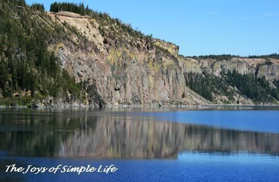
Crater Lake from Cleetwood Cove Trail
We know that most people see the beauty of Crater Lake from the rim only. All the pictures in my previous post about Crater Lake were taken from the rim's vista points and did not need any hiking at all. The first thing we do always whenever we visit a National Park is to stop at Visitor Center and talk to a Park Ranger. Park rangers are very helpful, with positive and cheerful mood, and oftentimes, they share their best kept secret to hike when asked, like our Valley Floor Loop Hike in Yosemite National Park. However, this time around, our question will not be on hiking, but water activities. We asked if we can go kayaking or canoeing at Crater Lake, and the park ranger smiled to us charmingly and answered no, but we can go swimming or fishing on the lake.
Fishing Pole, Crater Lake National Park, OR
( sorry, but I do not know the guy who has the pole, so I just have to take picture of his rod)
He told us that the boat going to Wizard Island starts mid-July so we can not go to Wizard Island either. We can go swimming if we do not mind the cold water. The only legal route to go to the lake shore is by way of Cleetwove Cove Trail, 2 miles round trip, 700 ft descent/ascent on steep slopes. It is the same trail taken by people who wishes to go to Wizard Island ( we would love to take that boat tour to Wizard Island, but it won't be open until July).
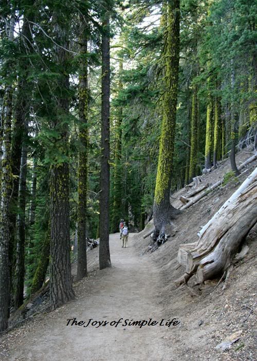
Cleetwood Cove Trail, Crater Lake National Park, OR
The picture of the trail above is my only picture of the trail despite I would have loved to take more pictures of the forested trail and the green lichens on the trunks of the trees. It was just so hard for us to take pictures, we could not stop to take pictures at all because the swarm of mosquitoes would cover our entire body. The moment I stopped for a picture, I would see my shirt and pants all black and covered with mosquitoes, my face attacked, so I would instead give up the thought of taking pictures and continue walking. I have a mosquito after bite lotion, but what we needed at that point was insect repellent, which was sitting there in our car. At the top, there was still snow, therefore, we did not see mosquitoes, so, our fault, we went down very excited and so unprepared for mosquito attack. We could turn around and take our repellent instead, but then, we were lazy too, and decided to just keep on. The hike was easy (except for some who are not used to steep slopes, it may be a little bit strenuous), but it became unforgiving because of the swarm of mosquitoes. Our hiking would have been probably more pleasant had we brought with us our insect repellent. When we reached the lake shore, there were fewer mosquitoes, so, we were able to take some pictures. Here are some pictures from the lake shore:
  The cold water felt so good! Even very close to the lake shore, the water was very deep!
Colored Cliffs
A Pose By the Cliffs
( smile, even if there are some mosquitoes, but mosquitoes on the shore are fewer than the trail, it's the forested trail that had lots of mosquitoes
Boats On Shore
Here are some pictures about 100 ft above the lake shore.
Men on Dock
Boat and Reflections on Crater Lake
After this spot, the trail has no more expansive view of the lake and become lined with tall trees and mosquitoes started to attack again, that I had to tell myself no more stopping for pictures! Both the uphill and downhill hike was without any pause for a deep breath at all, otherwise, mosquitoes will cover our entire body. 
Almost nearing the top back to parking lot, saw this little glimpse of the lake in the midst of trees
( despite the mosquitoes and blocked by trees, got to take this picture since this would be my last glimpse of the lake in this mosquito filled trail, and it is also the most sparkling blue I found )
A lesson learned from this hike: don't always forget to bring insect repellent especially if you are in moist areas, for no matter the conditions at the start of the trail, it may suddenly change. 

Saturday, October 04, 2014

For a change

For a change, some pictures from my city, sometimes, I do forget this part of our city, for I spend most of my leisure time in the nature part of our city. I am just glad that nature and civilization are not walled off from each other.
 Thus, beach and mountains are not vacation for me, they are my "to go" for relaxing in San Diego.

Friday, September 26, 2014

Hiking Vernal and Nevada Falls

from left to right: Back of Half Dome, Liberty Cap and Nevada Fall from John Muir Trail

Mileage: 7 miles round trip 
Elevation Gain: 2000 ft
Best Time: Late Spring to Early Summer, when the waterfalls are at their thunderous best.
Trailhead: at Happy Isles ( from the valley, take the Yosemite free shuttle bus and get off at Happy Isles)

Let me start this post with a quote from blogging friend Jo of Poetic Shutterbug: "Yosemite is God's country". Indeed, Yosemite is such a beautiful place and a sight to behold, it's more than just a great valley. Yosemite is one of the first wilderness National Parks in US ( 3rd after Yellowstone and Sequoia). Though it is most well known for its numerous waterfalls, but in Yosemite you will find nature's beauty and power through glacially carved massive granite rocks, an almost heaven on Earth meadows, pristine alpine lakes, giant sequoias, and miles of trails that wind through nature's beauty.   
When we were deciding before which trail to hike, Vernal and Nevada Fall or Yosemite Fall ( probably the most popular waterfall in Yosemite is the Yosemite Fall, North America's tallest waterfall), we considered the following information:
1. Yosemite Fall can be photographed from the valley. In fact, most of the people who visit Yosemite probably have seen only this waterfall thinking this is the only waterfall in Yosemite. 
Yosemite Fall from the Valley Floor
Vernal and Nevada Fall on the other hand cannot be photographed nor can be seen from the valley floor. One really has to exert an effort to take a glimpse of what it is like.
2. Hiking to the top of Yosemite Fall is more strenuous and more exposed to sun. Whereas, hiking to the top of Nevada Fall is mostly shaded by pine forest. 
3. On the day we were deciding which trail to hike next, we just finished a 13 mile Valley Floor Loop Hike plus a 4 mile round trip to Mirror Lake and Tenaya Canyon. With already tired feet, for about the same hiking mileage ( 7+ miles), a 2000 ft climb to Nevada Fall sounded better than the 2600 ft climb to the top of Yosemite Falls. 
4. We already have tons of pictures of Yosemite Fall from the valley but none of Nevada Fall. 
5. We will be back to hike Yosemite Fall and Half Dome via Cloud's Rest :)

So here goes a little bit more description of the hike to Vernal and Nevada Fall. Since you can find complete details of the Vernal and Nevada Fall hike at Yosemite Hikes, I will instead let our pictures speak for our experience.

From Happy Isles Stop to the footbridge of Vernal Fall is about 0.8 miles, 400 ft climb. This is the view from the footbridge when we were there. 
Vernal Fall From the Footbridge
( can you spot some of the people at the top of the waterfall? see how small they are compared to Vernal Fall?)
I met some tourists who probably did not do their research prior to this hike. They turned around from the footbridge very disappointed! Saying, "ahhhhh, I worked so hard for nothing!"- yes, because of the very thick leaves from the trees, the footbridge view is obstructed and the waterfall was hardly seen. What some of these tourists were meaning about working so hard was that a climb of 400 ft in 0.8 mile is very steep for those who are not much into uphill hiking and climbing stairs is a battle. But for those who did their assignment, they knew that there is so much more to Vernal fall beyond the footbridge.
After the footbridge, we continued hiking the Mist Trail, in another 0.5 mile and 400 ft climb, we were greeted with the unobstructed view of the Vernal Fall.
Unobstructed view of Vernal fall, less than 0.5 mile from the footbridge
Rainbow at the base of Vernal Fall 
( we got there at Vernal Fall between 10:00- 11:00 am, early summer or late June- but anyone can ask the park ranger at visitor Center at what time does rainbow appear in specific waterfalls because it varies with day and month of the year)
Vernal Fall and Rainbow
From the base of Vernal Fall, the trail climbs up over 600 steps over a steep granite stairway. The trail is very slippery here because of all the waterfall mist and spray. In about 0.7 miles from the footbridge, and 600 ft climb, we reached the top of Vernal Fall.
left to right: granite staircase, rainbow, and Vernal Fall from the top
At the top, there is a very scenic pool ( sorry, I forgot the name) where we stopped for our nutrition and hydration break.
Pool @ the top of Vernal Fall
( this pool is closed for swimming due to very close to Vernal Fall and some tourists who did not pay attention to the "no swimming signs" had lost their lives being swept by rushing current down to the fall )
After our nourishment break, we continued up the Mist Trail to the top of Nevada Fall. In less than half a mile from that pool above, we were greeted by the beauty of Nevada Fall.
Nevada Fall from the Mist Trail
Then, we continued up the rocky strewn slopes to get to the top of Nevada fall. For a while, we got lost of the sight of Nevada Fall in the trail, but we knew we were close because of all its thundering sound. When the trail opened to the sight of Nevada Fall again, we were again meandering an exposed trail of rocky strewn steep slopes.
Nevada Fall from the Exposed Rocky Strewn Trail
The Power of Nevada Fall 
( I took this picture with a fast shutter speed since I wanted to show the power and action of Nevada Fall. I usually use the cotton effect or slow shutter speed for waterfall shots when the waterfall is not as powerful and thunderous)
After about 1.2 miles and another 1000 ft climb from the top of Vernal Fall, we reached the top of Nevada Fall. Before reaching the top of Nevada Fall, there is a legal swimming hole where a lot of kids and other tourists stop to have a cool swim. This swimming hole is safe enough for swimming, but because we did not do our research, we did not have swimsuit, we passed the opportunity to swim in the frigid waters of Merced River. We instead moved away from the swimming crowd and seek a cooler place to enjoy the scenery with more solitude.
Where we stopped at the top to enjoy the fruits of our hike, this is where most hikers also refill their water container
When we were done resting and enjoying the scenery at the top of Nevada Fall, we looked down and looked back at where we've come from.
Looking Down and Back from Where We Came ( Though of Course we could not see the trailhead here)
Nevada Fall from the Top
Instead of returning the same route, we took the longer but less steep John Muir Trail. We had several purposes for taking a different trail, first is to photograph the very first picture above. The shot of Half Dome, Liberty Cap and Nevada Fall is from the John Muir Trail. Second was to see different scenery from a different trail. And third, it is friendlier to the knees to go downhill when the miles is longer since it means the slope is less steep. 

Here are my other posts about Yosemite and places near Yosemite: