While we were on our way to Crater Lake National Park, we had been planning to do some activities other than hiking. It is not that we got bored of hiking, but then, we were thinking of doing some water activities instead since we are visiting Crater Lake.
Crater Lake from Cleetwood Cove Trail
We know that most people see the beauty of Crater Lake from the rim only. All the pictures in my previous post about
Crater Lake were taken from the rim's vista points and did not need any hiking at all. The first thing we do always whenever we visit a National Park is to stop at Visitor Center and talk to a Park Ranger. Park rangers are very helpful, with positive and cheerful mood, and oftentimes, they share their best kept secret to hike when asked, like our
Valley Floor Loop Hike in Yosemite National Park. However, this time around, our question will not be on hiking, but water activities. We asked if we can go kayaking or canoeing at Crater Lake, and the park ranger smiled to us charmingly and answered no, but we can go swimming or fishing on the lake.
Fishing Pole, Crater Lake National Park, OR
( sorry, but I do not know the guy who has the pole, so I just have to take picture of his rod)
He told us that the boat going to Wizard Island starts mid-July so we can not go to Wizard Island either. We can go swimming if we do not mind the cold water. The only legal route to go to the lake shore is by way of Cleetwove Cove Trail, 2 miles round trip, 700 ft descent/ascent on steep slopes. It is the same trail taken by people who wishes to go to Wizard Island ( we would love to take that boat tour to Wizard Island, but it won't be open until July).
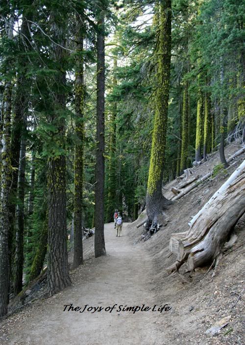
Cleetwood Cove Trail, Crater Lake National Park, OR
The picture of the trail above is my only picture of the trail despite I would have loved to take more pictures of the forested trail and the green lichens on the trunks of the trees. It was just so hard for us to take pictures, we could not stop to take pictures at all because the swarm of mosquitoes would cover our entire body. The moment I stopped for a picture, I would see my shirt and pants all black and covered with mosquitoes, my face attacked, so I would instead give up the thought of taking pictures and continue walking. I have a mosquito after bite lotion, but what we needed at that point was insect repellent, which was sitting there in our car. At the top, there was still snow, therefore, we did not see mosquitoes, so, our fault, we went down very excited and so unprepared for mosquito attack. We could turn around and take our repellent instead, but then, we were lazy too, and decided to just keep on. The hike was easy (except for some who are not used to steep slopes, it may be a little bit strenuous), but it became unforgiving because of the swarm of mosquitoes. Our hiking would have been probably more pleasant had we brought with us our insect repellent. When we reached the lake shore, there were fewer mosquitoes, so, we were able to take some pictures. Here are some pictures from the lake shore:

The cold water felt so good! Even very close to the lake shore, the water was very deep!
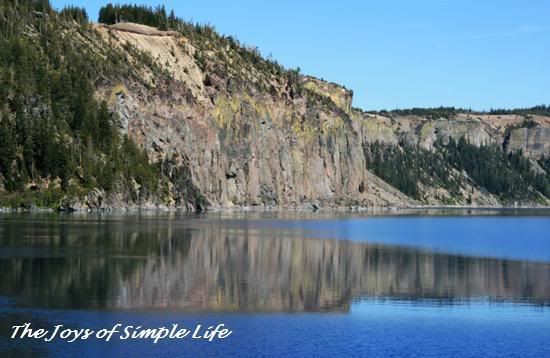
Colored Cliffs
A Pose By the Cliffs
( smile, even if there are some mosquitoes, but mosquitoes on the shore are fewer than the trail, it's the forested trail that had lots of mosquitoes)
Boats On Shore
Here are some pictures about 100 ft above the lake shore.
Men on Dock
Boat and Reflections on Crater Lake
After this spot, the trail has no more expansive view of the lake and become lined with tall trees and mosquitoes started to attack again, that I had to tell myself no more stopping for pictures! Both the uphill and downhill hike was without any pause for a deep breath at all, otherwise, mosquitoes will cover our entire body.
Almost nearing the top back to parking lot, saw this little glimpse of the lake in the midst of trees
( despite the mosquitoes and blocked by trees, got to take this picture since this would be my last glimpse of the lake in this mosquito filled trail, and it is also the most sparkling blue I found )
A lesson learned from this hike: don't always forget to bring insect repellent especially if you are in moist areas, for no matter the conditions at the start of the trail, it may suddenly change.


 Sea stars