Saturday, December 31, 2011

Enjoying the Gift of Simple Fun This Christmas


Fun Can Be As Simple As This.......
Torrey Pines State Natural Reserve, San Diego, CA
"What gift do you want this Christmas?"- my hubby asked. 
My response was quick....... 
" I could not think of any dear....I have everything in my heart and in my mind. Just the gift of time, having fun out of the doors and enjoying the simple pleasures in life with you."
2 Kids-at Heart Having Fun Doing Synchronized Leaping
So, for the past 7 days since day 1 of my 2-weeks holiday or Christmas break, we had been wandering in and around San Diego with some family to enjoy each other's gift of enjoying simple fun, taking all stresses away. What gift do I want for Christmas? 
 Jumping
I love the priceless gift of time and sharing activities together with loved ones, exploring the many joys together that we can find from our natural world.
Christmas was never about material things for me. The birth of Jesus Christ showed us God's gift of family togetherness wrapped around not by material riches but by love. For the past 7 to 8 days, we had walked, jumped and leaped about a hundred miles, maybe not as much mileage as what these dolphins had done,

we hiked or climbed up several thousands feet closer to the sky,
Hiking @ El Cajon Summit Trail, El Capitan Open Space Reserve, Lakeside, San Diego County
and we sure had a whale of a good time wandering around home sweet San Diego.

Have a Merry Christmas and Happy Holidays Everyone. Thank you always for your visits to my site, they sure added priceless joy to every pages of my life.

Saturday, December 17, 2011

Remembering Manzanar

Vast Emptiness at Manzanar National Historical Site
As we stood in the middle of this vast emptiness, we felt the coldness ( well, it was really cold with temperature in the 30s or near freezing) and the isolation. Can you imagine living in the middle of this desert emptiness, so hot in the summer ( temperature soars up to over 100s F or high 30s-40s C) and freezing cold in the winter, living in barracks where sands from howling winds could get in, where the holes on the wall and roof could not protect you from the searing heat and biting cold?
In 1942, about 120,000 Japanese Americans were uprooted from their homes and were given about one week to dispose of whatever they owned, except what they could pack and carry for their departure by bus...to this vast desert valley, at Manzanar.
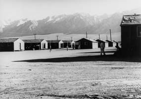
Entrance of the Internment Camp (click here to see pictures of barracks before that were all gone now)
The relocation of Japanese into this internment camp also uprooted the Pauite Indians and early settlers of Owens Valley from their homes.  Though Owens Valley is a vast desert region, but the snow capped Sierra Nevada Mountains produces so much small streams that creates surprising regions of riparian green habitat that allowed easy farming for early Pauite Indian settlers to raise cattle, sheep, fruit, wheat and other crops.
Snow Capped Sierra Nevada Mountains to the West

Snow Capped Desert Mountain to the East of Manzanar
Manzanar is the Spanish word for "apple orchard", and the town of Manzanar was developed as an agricultural settlement beggining 1910. Early settlers grew apples, pears, peaches, potatoes and alfala on several thousand acres surrounding the town.
 What Remains of the Farm and Apple Orchard

The Los Angeles Department of Water and Power began acquiring water rights in the valley, and by 1920, Los Angeles owned all of Manzanar's land and water rights. Within five years, the early settlers and farmers were exiled from their town. Manzanar became an abandoned town.
Road to Nowhere? This bareness gave a chilling shock imagining how vast, isolated, and brutal the conditions were for Japanese who were interned here. 
In 1941, Japan's attack on Pearl harbor led the US into World War II and radically changed the lives of 120,000 Japanese American living in the United States. In 1942, the US Army leased 62,000 acres at Manzanar from Los Angeles to establish a center that will hold Japanese Americans during World War II. This is where the Japanese were brought to be isolated from the rest of the Americans.
Manzanar National Historic Site was established to preserve the stories of the internment of Japanese in the US during World War II and to serve as a reminder of the fragility of American Liberties. Though this historic site is now bare throughout the grounds, and the few structures left were concrete foundations, ruined water system, 
Japanese gardens, 

Some of the Japanese Garden in the Internment Site
I was told in the Visitor Center that the garden in the above picture won 3rd place based from the records of Japanese internees. To fight off the isolation, Japanese enjoyed nature by having garden contests, availed of the vast area by playing baseball, etc.
and cemetery.
Cemetery

The short 22-minute film, "Remembering Manzanar" is shown at the visitor center every 30 minutes. The film is very powerful in sending the message of the painful experiences of the Japanese who lived here in the camp surrounded by barbed wired-fences. Up until now, I still can almost hear the voice of the man who were sharing his first night at the camp.
 "The first thing we were asked to do was to fill the sack with straw. That would be our bed. Night came and I saw holes up the roof. I saw stars, so BEAUTIFUL. Morning, we woke up with sand all over us. The desert, it is so brutally hot in the summer, bone chilling cold in the winter, and there was always the sand and the WIND."- some words that haunted me after watching "Remembering Manzanar."
 Manzanar National Historic site is one of more than 380 parks in the National Park System. The National Park Service cares for these places saved by the American people so that all may experience America's natural resources, history and heritage.
I could not help but feel sad while walking in the trails of Manzanar, sad and inspired that despite the difficulties of the Japanese people at that time, they continued to be strong, and loyal to the country they still feel they belong, the United States of America. 
One of the exhibits that brought so much tears of inspiration, were American teachers who worked with the education of children in the camp, because, these children were also children of America. 
American Teachers for Japanese Children Continuing Education
Teachers recruitment and retention were difficult then considering the isolation of Manzanar but a few chose to remain moved by so many children uprooted from their normal lives. The teachers who remained dedicated themselves to bringing hope for better future.
The words above were so powerful for me that my heart became congested and eyes misty. The mistakes of the past is painful and heart ripping, but am glad the nation's history acknowledges this mistake that serves as a touching lesson. Forty six years after the Japanese internment, in 1988, congress passed, and signed by then President Ronald Reagan, a legislation which apologized for the Japanese American internment in behalf of the US government. The legislation said that the government actions were based on "race prejudice, war hysteria, and a failure of political leadership.". The US government eventually disbursed more than $1.6 billion in reparations to Japanese Americans who had been interned and their heirs.

The Park is along Hwy 395, about 13 miles North of Lone Pine or 6 miles South of Independence. If you are interested to revisit this part of history, Manzanar National Historic Site should be an easy find if you are visiting the Eastern Sierra, where you can access two National Parks: Yosemite National Park to the West and Death Valley National Park to the East.


Tuesday, December 13, 2011

So Much To Be Thankful For

Geographical Contrast in the Eastern Sierra, at Bishop, California
Happy thanksgiving everyone! We just came back from a 5 day desert get-away at the Eastern Sierra. We had such a wonderful time hiking and exploring the Sierras. As always, exploring the contrasts and features of nature always give a sense of peacefulness within that strengthens and inspires the heart.
Enjoying the Geographical Diversity in this Planet Earth at the Eastern Sierra, CA
Life has been great so far, though there are a lot of challenges, but there are more joys and happiness. I guess, it is these challenges that bring deeper joy when we are able to survive them and conquer. Like a hike, the joy is not only on reaching the destination, but the entire journey, how we learn and keep on gaining wisdom from each lesson of life. Life is beautiful, there is just so much to be thankful about. I always feel thankful for the love of family and friends, and always grateful for our good health. I also am so thankful for having the energy and the heart to explore the joys in our wonderful world behind the back roads. 
I am hoping to be able to share more details of the places we experienced in the Eastern Sierra in my later posts. I just would want to take this chance to greet you all a Happy Thanksgiving.

Monday, December 12, 2011

Barker Dam Loop Trail, Joshua Tree National Park

Barker Dam, Joshua Tree National Park
Mileage: 1.5 mile loop 
Difficulty: Very Easy level walk (with only about 100 ft elevation gain), however, for those who wanted to add challenge can scramble up in this rocky wonderland trail.
Trailhead: Park Blvd (12 miles west of the intersection with Pinto Basin Road), Joshua Tree National Park, CA ( less than 2 hours drive from Los Angeles or San Diego, a few minutes away from Palm Springs )
Me and Joshua Tree
The Barker Dam Loop Hike is a fun and easy hike for all members of family. There are two trails that cross at the trail head, be sure to follow the signs that lead to Barker Dam. In the first part of the trail, you will be passing Joshua Trees, which are the largest of the yucca family and grows primarily in the Mojave Desert. 
 Joshua Tree 
Joshua Tree and all other yuccas are members of the lily family. Notice in the picture above how the limbs of the yucca bend down already from its weight. Joshua Tree National Park is world famous for rock climbers though it started before as winter ground for Yosemite rock climbers. It is not a surprise to see rock climbers dotting the surface of the rocks as you walk on the trail to Barker Dam, or anywhere in the Park. 
 Rock Climber at Joshua Tree
Want To Rock Climb?
 We are not technical rock climbers, however, whenever there is an opportunity to scramble on rocks and boulders, we love doing so. There are many opportunities for rock scrambling and bouldering in this park. The Barker Dam Loop Trail is in interpretative trail, and if you pay attention to the signs, you will not miss the petroglyphs that have been left behind by past civilization, but have been vandalized or painted over :(
 Petroglyphs Painter Over :( 
 After a short while of walking in the midst of wall of rocks and Joshua Trees, the calm blue dam (or much more like a pond) is very welcome sight.
Barker Dam
This dam is a naturally enclosed area of steep rock formations and boulders that form a bowl at the center, thus the early settlers of the park built a 20-ft long 10-ft high cinder block wall to fully enclose the area keeping the water in for horses and cattle to eat and drink.
This is a popular spot for the desert big horn sheep to get their fill of water. However, because the desert big horn sheep generally shy away from human interaction, the Barker Dam Loop Trail is closed during sunrise and sunset, the time at which these endangered animals come down from the mountain to get their fill of drink.
For more about this park, visit my two previous posts:
1. Desert Wilderness at Joshua Tree National Park
2. The Joshua Tree

Wednesday, November 23, 2011

Eastern Sierra, California and Alicante, Spain

Whenever I explore places, I try also to imagine some places that may share some similarity. Doing this makes me feel like I have been to many places at one time. Having not enough time, resources and energy to explore all places in the world, when I take a hike, I close my eyes and transport myself to another place sometimes. Perhaps, very similar to the contrasting geography and weather in California is Alicante, Spain. Most of the province of Alicante has semi-arid environment such as the deserts of Eastern Sierra, East of the central and southern part of California.
   Dawn at Mono Lake South Tufa State Reserve, Lee Vining, CA
Whereas the Northeastern part of Alicante bordered by the sea has true Mediterranean weather like the coastal region of Southern California. Their mountain regions are also not spared from snow just as California mountains. 
 Desert and Snow, The Geographical Diversity in Eastern Sierra, CA
The Mediterranean weather closer to the ocean, the sand dunes in arid valleys and four seasons mountains provide so much geographical diversity in Alicante.  Since getting to Alicante has been made easier by the region's excellent transport networks, its natural features and culture make it one of the most surprising and visited provinces in Spain.
The similarity of the geographical contrasts in California, Alicante, and in most other places remind us that Earth is beautiful wherever we may be if we open ourselves to the beauty of the natural world that surrounds us. 
Because I have not been to Alicante yet, let me share with you our recent California get-away, in the Eastern Sierra. What makes the Eastern Sierra so unique is that this desert environment has so much small streams from the snow covered mountains that creates a vast desert landscape with surprising regions of riparian green habitat that provides a refuge to a diverse wildlife. 
From the lowest point in Northern America to the highest point in the contiguous US, there is so much diversity in the Eastern Sierra that is a geological wonderland to a keen observer.          
 Lowest Point in Northern America at  Badwater Basin, Death Valley National Park, CA                
 Highest Point in Contiguous US, Mt Whitney, Sequoia National Park, CA
(but photographed from Alabama Hills, Lone Pine, CA)
There are so many geological features in Eastern Sierra and so many trails that vary from desert to alpine environment. What I will share in this post is a glimpse to our 4-day unplanned getaway just recently. 

Day 1: From San Diego to Lone Pine via Death Valley National Park.                                         
Darwin Falls, Panamint Springs, Death Valley National Park
Day 2: Lone Pine to Bishop                                      
  Sunrise at Lone Pine, Eastern Sierra, CA                                       
 Manzanar National Historical Site, Eastern Sierra, CA                                        
Day 3: Bishop to Lee Vining                                      
Pleasant Valley Dam, Owens River, Bishop, CA
   Bishop Creek Canyon                                      
 Contrasting landscape, Bishop                                         
 Dusk at Mono Lake, Lee Vining, CA
Day 4: Lee Vining to Lone Pine                                      
Mono Lake, dawn                                      
  Hot Creek Hot Springs, Mammoth Lakes, CA                                      
 Eureka Sand Dunes, Death Valley National Park, CA
Day 5: Trip back to San Diego from Lone Pine.
Home Sweet San Diego
Now, back to enjoying the sea.
I am just glad that though the ocean is our backyard in San Diego, but the mountains and the desert is just nearby.

Just like Alicante, Spain!